Log in
All resources
Create a design
2,977 Free Artworks of City Map
maps in the library of congress
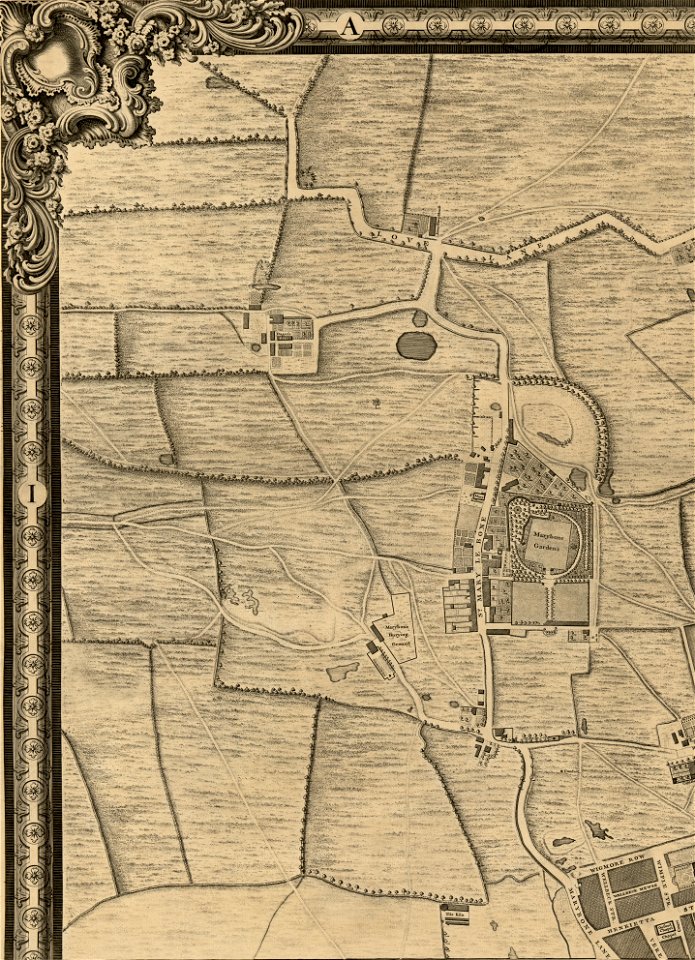
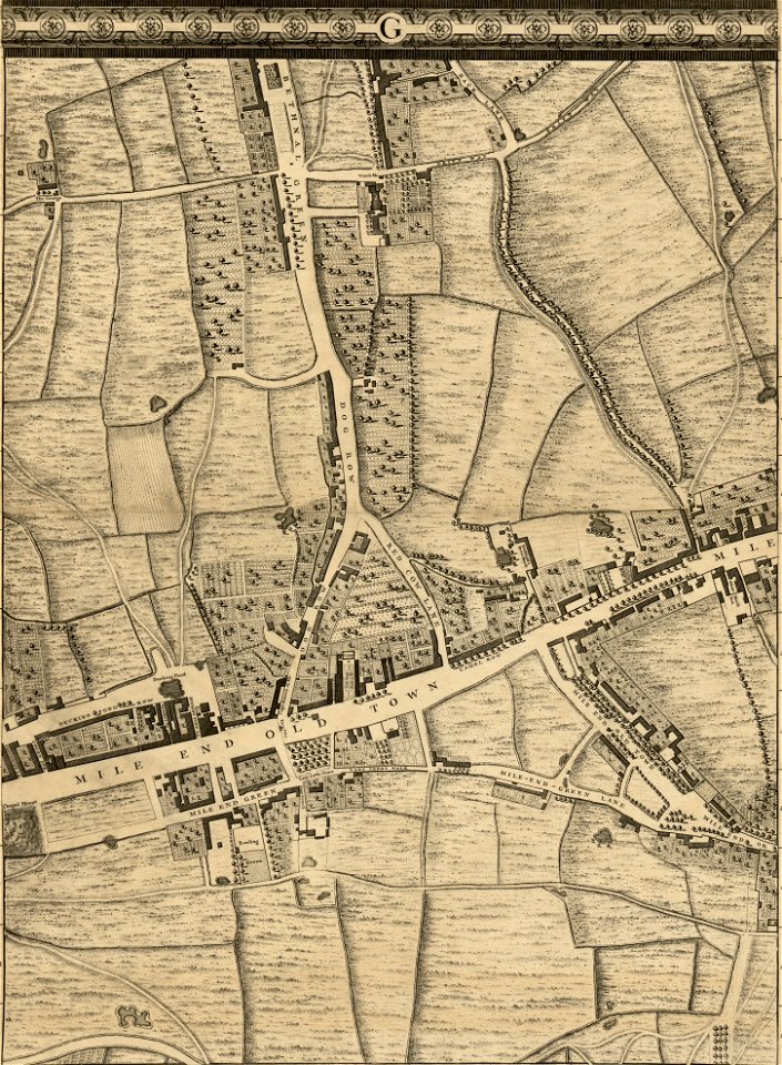
john rocque 1746 crops from library of congress
john rocque's maps of london
john rocque
civitates orbis terrarum. urbium praecipuarum totius mundi. liber quartus
drawing
digital library of university of wroclaw
maps from university of amsterdam special collections
atlas der neederlanden
atlas der neederlanden deel ii: holland 1. zuid-holland
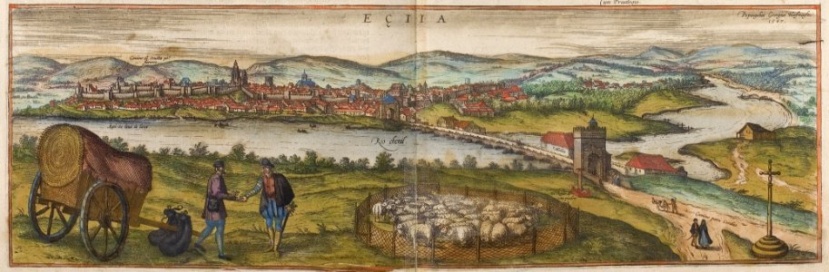
maps of écija by braun & hogenberg
andalusia in the 1570s
historical images of tarragona
anthonis van den wijngaerde
truscott map of st-petersburg 1753
nevsky prospect
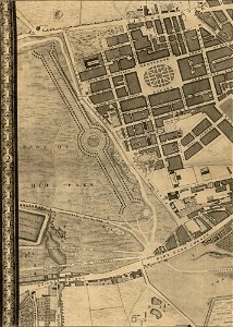
john rocque 1746 crops from library of congress
maps in the library of congress
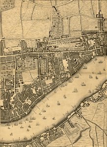
john rocque 1746 crops from library of congress
maps in the library of congress
john rocque 1746 crops from library of congress
maps in the library of congress
john rocque 1746 crops from library of congress
maps in the library of congress
john rocque 1746 crops from library of congress
maps in the library of congress
john rocque 1746 crops from library of congress
maps in the library of congress
john rocque 1746 crops from library of congress
maps in the library of congress
john rocque 1746 crops from library of congress
maps in the library of congress
john rocque 1746 crops from library of congress
maps in the library of congress
john rocque 1746 crops from library of congress
maps in the library of congress
john rocque 1746 crops from library of congress
maps in the library of congress
john rocque 1746 crops from library of congress
maps in the library of congress
john rocque 1746 crops from library of congress
maps in the library of congress
john rocque 1746 crops from library of congress
maps in the library of congress
john rocque 1746 crops from library of congress
maps in the library of congress
maps of peñón de vélez by braun & hogenberg
maps of tunis by braun & hogenberg
john rocque 1746 crops from library of congress
maps in the library of congress
john rocque 1746 crops from library of congress
maps in the library of congress
john rocque 1746 crops from library of congress
maps in the library of congress
john rocque 1746 crops from library of congress
maps in the library of congress
john rocque 1746 crops from library of congress
maps in the library of congress
john rocque 1746 crops from library of congress
maps in the library of congress
john rocque 1746 crops from library of congress
maps in the library of congress
maps of venlo by willem and johannes blaeu
venlo in the 17th century
maps of dresden by braun & hogenberg
maps of leipzig by braun & hogenberg
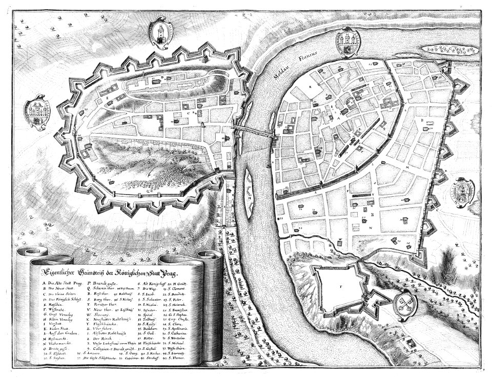
engravings of topographia bohemiae moraviae et silesiae
baroque
asia noviter delineata
old goa
history of hormuz island
asia noviter delineata
kaiserdom st. bartholomäus in the 19th century
maps of frankfurt-innenstadt
1704 works in germany
old maps of ulm
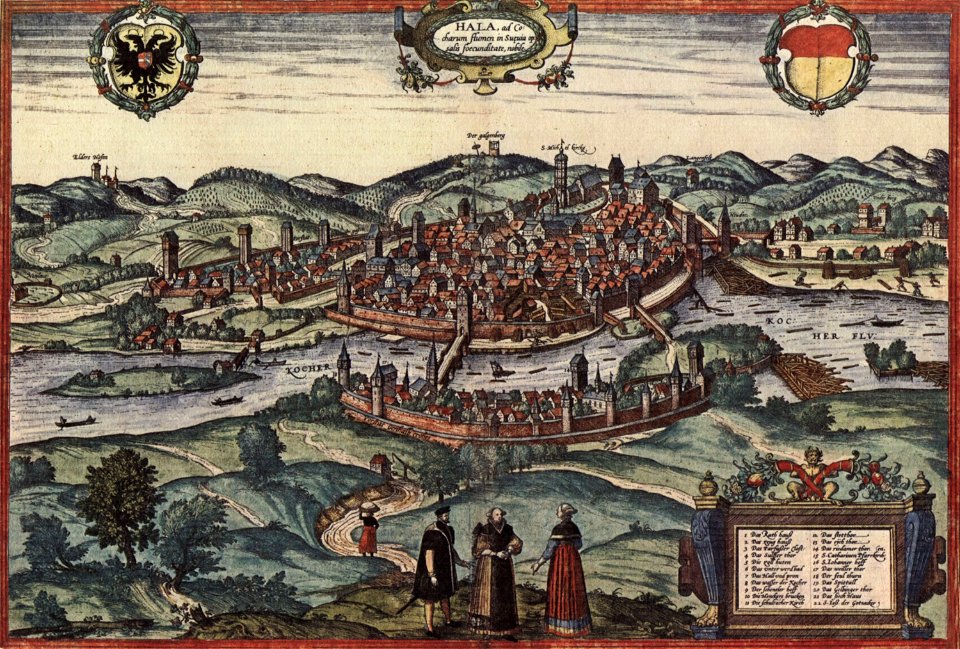
maps of schwäbisch hall by braun & hogenberg
maps of diu by braun & hogenberg
diu, india
bibliothèque nationale de france
1698 map of evesché de meaux
maps of gdańsk by braun & hogenberg
city walls of gdańsk
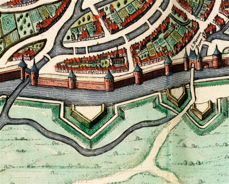
maps of liège by johannes blaeu - derivative files
city walls of liège
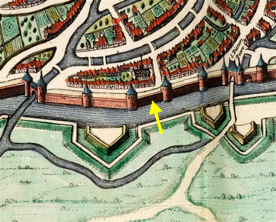
maps of liège by johannes blaeu - derivative files
city gates in liège
maps of brest, france by antoine aveline
brest (france) in the 1700s
maps in the british museum
salomon de bray
maps by emanuel bowen
1740 maps
atlas van der hagen (volume 3)
atlas van der hagen
maps by nicolaes visscher i
old maps of canaan
map of maastricht by willem and johannes blaeu (1649)
atlas beudeker
maps from university of amsterdam special collections
atlas der neederlanden
maps from university of amsterdam special collections
atlas der neederlanden
maps from university of amsterdam special collections
atlas der neederlanden
maps from university of amsterdam special collections
atlas der neederlanden
maps from university of amsterdam special collections
atlas der neederlanden
maps from university of amsterdam special collections
atlas der neederlanden
1890s maps of the caribbean
brethren of the coast
postcards of elk city, oklahoma
curt teich postcard archives
portuguese macau
1665
coats of arms of orléans
gaspard de coligny
19th-century maps of haute-saône
coats of arms of vesoul
victor levasseur - maps of france
old maps of gironde
19th-century maps of loire-atlantique
pierre cambronne
pierre terrail de bayard
casimir pierre perier
historical images of the grand place
breadhouse (brussels) in art
asia noviter delineata
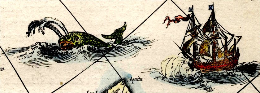
1617 drawings
asia noviter delineata
muscovy
asia noviter delineata
sumatra in art
geometrischer grundriss von frankfurt am mayn (1811)
maps of frankfurt-innenstadt
commonwealth (ship, 1854)
steamboat advertising
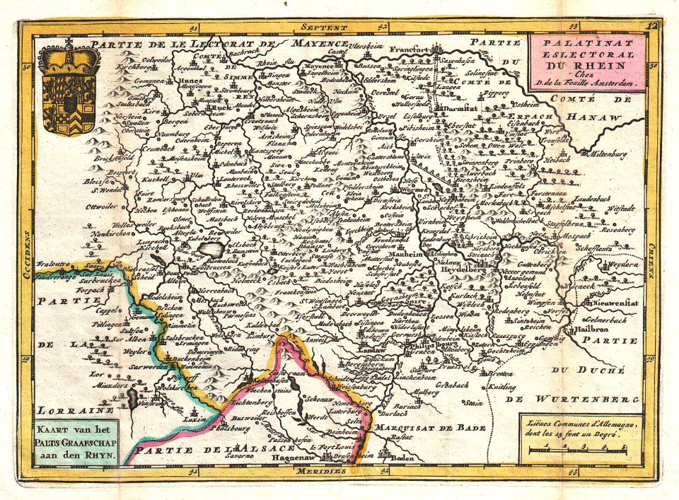
old maps of rhineland-palatinate
daniel de la feuille
civitates orbis terrarum. urbium praecipuarum totius mundi. liber quartus
16th-century maps showing history
civitates orbis terrarum. urbium praecipuarum totius mundi. liber quartus
maps of husum by braun & hogenberg
civitates orbis terrarum. urbium praecipuarum totius mundi. liber quartus
maps of eisleben by braun & hogenberg
civitates orbis terrarum. urbium praecipuarum totius mundi. liber quartus
maps of mâcon by braun & hogenberg
civitates orbis terrarum. urbium praecipuarum totius mundi. liber quartus
maps of dortmund by braun & hogenberg
civitates orbis terrarum. urbium praecipuarum totius mundi. liber quartus
maps of oberwesel by braun & hogenberg
civitates orbis terrarum. urbium praecipuarum totius mundi. liber quartus
16th-century maps showing history
civitates orbis terrarum. urbium praecipuarum totius mundi. liber quartus
maps of krempe by braun & hogenberg
civitates orbis terrarum. urbium praecipuarum totius mundi. liber quartus
maps of sulmona by braun & hogenberg
civitates orbis terrarum. urbium praecipuarum totius mundi. liber quartus
maps of itzehoe by braun & hogenberg
civitates orbis terrarum. urbium praecipuarum totius mundi. liber quartus
maps of marchena by braun & hogenberg
civitates orbis terrarum. urbium praecipuarum totius mundi. liber quartus
maps of hamburg by braun & hogenberg
civitates orbis terrarum. urbium praecipuarum totius mundi. liber quartus
1590s maps of denmark
civitates orbis terrarum. urbium praecipuarum totius mundi. liber quartus
maps of brixen by braun & hogenberg
map of maastricht by willem and johannes blaeu (1649)
jekerkwartier (maastricht)
map of maastricht by willem and johannes blaeu (1649)
jekerkwartier (maastricht)
18th-century maps of strasbourg
1740s maps of france
portolan charts by willem and johannes blaeu
latin-language maps
plan de la ville et faubourg de paris, divisé en ses 48 sections by mondhare & jean
maps of paris from paris musées
maps of alexandria by braun & hogenberg
maps in the british museum
maps from university of amsterdam special collections
atlas der neederlanden
maps from university of amsterdam special collections
atlas der neederlanden
maps from university of amsterdam special collections
atlas der neederlanden
ghosts & ghoulish scenes
museum für kunst und kulturgeschichte
maps of dortmund by braun & hogenberg
maps of paris from paris musées
baroque
old maps of bordeaux
burdigala
the history and antiquities of the parish of lambeth, and the archiepiscopal palace (1827)
1820s maps of london
maps from university of amsterdam special collections
atlas der neederlanden
maps from university of amsterdam special collections
atlas der neederlanden
maps of goa by linschoten
maps
maps of flensburg by braun & hogenberg
city gates in flensburg
pompeiana - the topography, edifices, and ornaments of pompeii (1817)
old maps of campania
maps from the earth and its inhabitants, vol. xvi
19th-century maps of mexico city
1101 - 1200 of 2,977
Next page
/ 30